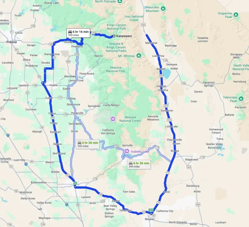
Pull up Google Maps and ask it to route you from Kanawyers to Independence, California. Watch what happens next. The blue line doesn’t go straight. It doesn’t even go close to straight.
It swings dramatically south through the Central Valley, skirts the edge of the Mojave Desert, loops around the bottom of one of the most formidable mountain ranges in North America, and climbs back north along US Route 395 — arriving at a destination that, on a straight line, was never more than 20 miles away.
The total distance: 350 miles. The total drive time: six hours.
Welcome to one of America’s most quietly astonishing geographical quirks — a story that has been going viral in travel circles since early 2026, and one that says something profound about the raw, unconquered power of California’s Sierra Nevada mountains.
The Wall Between Them
The Sierra Nevada mountains between Kanawyers and Independence rise above 13,000 feet, including peaks such as Mount Williamson and Mount Tyndall. This section of the range has no roads crossing it.
Mount Whitney — the tallest mountain in the contiguous United States at 14,505 feet — stands almost directly between the two towns. The terrain is so vertical, so exposed and so technically demanding that engineers have never attempted to build a road across it. Not in the automobile era. Not ever.

Kanawyers sits at the end of Highway 180 inside Kings Canyon National Park, tucked into the western side of the range. Independence occupies the eastern side of the Sierra, a quiet Inyo County seat on a different geological world entirely. Both towns are small. Both are beautiful. And neither has any practical direct road connection to the other.
The Only Way Around Is the Long Way Around
To drive between the two towns by car, drivers must head west out of Kings Canyon, wind down through California’s Central Valley, swing south toward Bakersfield, skirt the edge of the Mojave Desert and then climb back north along US Route 395 on the eastern side of the Sierra.
It is, as one travel writer put it, “a comically long detour” — but one that reveals something remarkable about how mountains still shape human movement in the 21st century.
What Hikers Can Do That Drivers Cannot
Here is where the story gets genuinely poetic. While a driver spends six hours covering 350 miles, a backpacker with a good pair of boots and a week’s worth of food can cross the same 20 miles on trail — passing through some of the most breathtaking high Sierra wilderness in the country.
The John Muir Trail and the Pacific Crest Trail both pass through this corridor, carrying thousands of hikers each year through Kings Canyon and the Inyo backcountry. For those willing to carry a tent, the “shortcut” exists. For everyone else, the mountains win.
Why This Story Matters for Travelers
California’s Sierra Nevada is often experienced as a backdrop — visible from freeways, photographed from overlooks, admired at a distance. The Kanawyers-Independence story forces a different kind of reckoning.
It is a reminder that some geography has never been tamed. That roads are not inevitable. That between two points that appear close on a map, an entire world of granite, ice and altitude can make the straight line completely irrelevant.
For road trip planners visiting Kings Canyon or the Eastern Sierra in 2026, this quirk carries a very practical implication: do not assume that nearby towns on opposite sides of the range are easy day trips from each other. Check the route. Check the elevation. The Sierra Nevada has been humbling travelers for centuries, and it has no intention of stopping.
Sources: Bakersfield Today, “Two California Mountain Towns Separated by 350-Mile Drive,” March 16, 2026 · Yahoo Travel, “These California towns are just 20 miles apart but it’s a 350-mile drive,” March 17, 2026