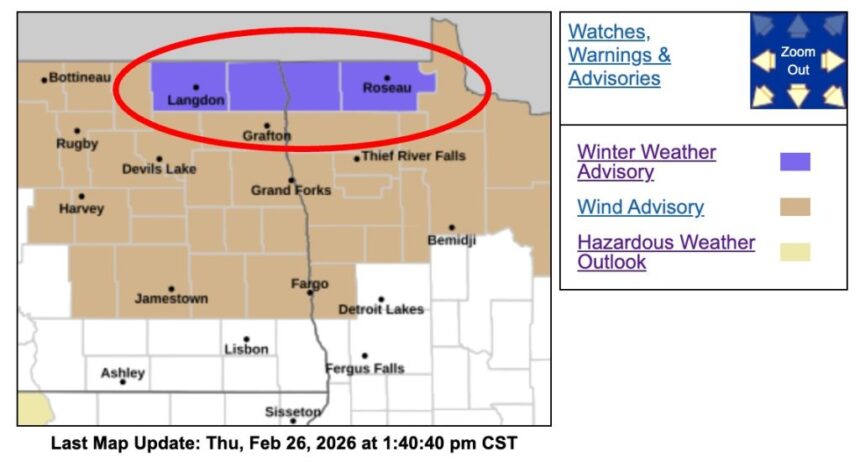
The National Weather Service (NWS) has issued a Winter Weather Advisory for four northern counties in Minnesota and North Dakota, warning of blowing snow and dangerous travel conditions through Friday evening.
According to the National Weather Service in Grand Forks, the advisory will be in effect from 9 a.m. to 7 p.m. CST Friday for Kittson and Roseau counties in Minnesota, as well as Cavalier and Pembina counties in North Dakota. Forecasters say strong winds and widespread blowing snow could create near-blizzard conditions in open country, particularly in rural areas.
The advisory, issued Thursday afternoon, highlights wind gusts that may reach as high as 55 miles per hour, significantly reducing visibility in exposed areas. “Blowing snow is expected, with potentially near blizzard conditions in open country,” the NWS stated in its urgent winter weather message. Officials emphasized that hazardous conditions will likely impact the Friday evening commute, especially on north-south roadways where crosswinds could be strongest.
Communities included in the advisory area are Cavalier, Hallock, Langdon, Drayton, and Roseau. While heavy snowfall is not the primary concern, the combination of existing snow cover and powerful winds is expected to create drifting snow and whiteout conditions at times.
Meteorologists explain that open farmland and rural highways are particularly vulnerable to sudden drops in visibility. Even brief whiteout conditions can make travel treacherous. Drivers may encounter drifting snow across roadways, leading to slick spots and reduced traction.
The National Weather Service advises residents to use caution while traveling, especially in open areas. Motorists are encouraged to check updated road conditions before heading out. The agency recommends calling 511 for the latest state-specific highway information.
Though the advisory does not rise to the level of a winter storm warning, officials caution that blowing snow can be just as disruptive as heavy snowfall. High winds may also cause minor property damage, particularly to unsecured outdoor items.
Weather patterns across the Northern Plains have remained active this week, with fluctuating temperatures and passing systems contributing to shifting snow conditions. Forecasters say the current advisory is tied to a strong pressure gradient moving through the region, generating intense wind speeds capable of lifting loose snow into the air.

Emergency management officials urge residents to prepare by allowing extra travel time, keeping emergency kits in vehicles, and avoiding unnecessary trips during peak wind periods. Those traveling in rural areas should be especially vigilant, as visibility can change rapidly within short distances.
The National Weather Service continues to monitor conditions and will provide updates if the situation intensifies. Residents are encouraged to stay informed through official NOAA weather channels and local emergency alerts.
As winter weather continues to affect the Northern Plains, authorities stress the importance of preparedness and caution. Even in the absence of heavy snowfall, strong winds and blowing snow can create dangerous and unpredictable travel conditions, making awareness and planning essential for community safety.