Satellite imagery analyzed in recent weeks is raising fresh concerns about the scale of the upcoming sargassum season in the Caribbean, with scientists now warning that the situation may be significantly more severe than previously reported.
Earlier estimates indicated that approximately seven million tons of sargassum were moving across the tropical Atlantic toward the Caribbean Sea.
Updated observations now suggest the volume has continued to increase, pointing to what could become one of the largest sargassum influxes on record.
The latest assessment is based on high-resolution satellite data showing expansive and increasingly dense mats of sargassum stretching across the central and western Atlantic Ocean.
These floating accumulations are part of the Great Atlantic Sargassum Belt, a recurring phenomenon first identified in 2011. According to recent imagery, the belt appears wider and more concentrated than earlier this season, significantly raising the probability that large quantities will reach Caribbean coastlines in the coming weeks.
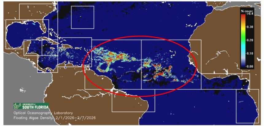
A principal source of this analysis is the Optical Oceanography Laboratory at the University of Florida, a research center internationally recognized for its work in satellite-based ocean observation and marine remote sensing. The laboratory specializes in analyzing how light interacts with ocean waters and has developed advanced methods to detect, track, and estimate the biomass of floating sargassum from space. Using data from NASA and international satellite platforms, its scientists provide regular monitoring and seasonal outlooks that are widely referenced across the Caribbean region.
According to the laboratory’s most recent reports, sargassum biomass in the tropical Atlantic is already well above historical averages for this time of year. Researchers note that while not all sargassum detected by satellites will ultimately make landfall, the unprecedented scale currently observed increases the likelihood of prolonged and widespread coastal impacts throughout the Caribbean basin.
In the Mexican Caribbean, early indications of this forecast are already visible. Beaches along the coast of Quintana Roo, including areas near Cancún, Playa del Carmen, Puerto Morelos, and Tulum, have experienced intermittent sargassum arrivals in recent weeks. In several locations, offshore accumulations have grown, suggesting heavier beaching events may occur as prevailing currents and seasonal winds continue to push the algae westward.
Local authorities and the tourism sector have responded by intensifying monitoring, cleanup operations, and the deployment of offshore containment barriers. Environmental specialists caution, however, that sustained landings can affect coastal ecosystems, water quality, and local economies, particularly if arrivals persist over several months.
As satellite imagery continues to be updated, scientists stress that early awareness and preparedness remain critical. While uncertainty remains regarding the exact timing and severity of landings, current data indicate conditions are already worse than earlier projections of seven million tons.
The evolving situation highlights the growing importance of satellite science in anticipating environmental challenges that are becoming an increasingly regular feature of the Caribbean region.