A tornado watch has been issued for large portions of Florida, Alabama, and Georgia, as a volatile weather system moves across the southeastern United States, according to the National Weather Service (NWS).
UPDATE: 2 separate tornadoes reported!
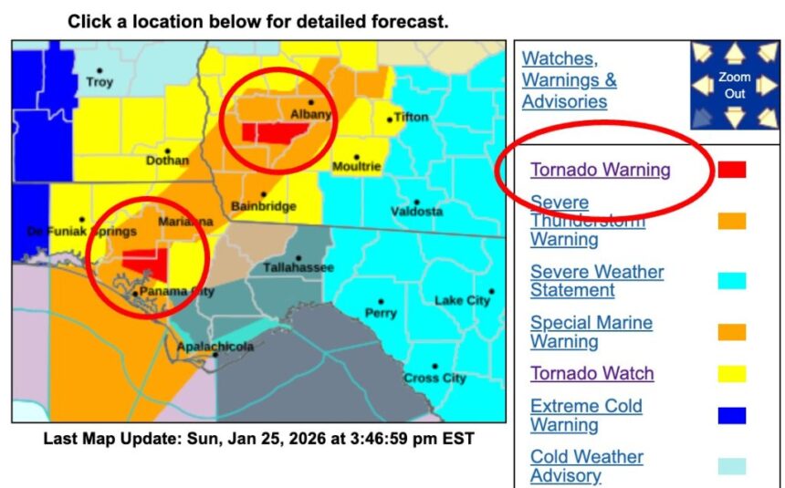
In Florida, a tornado warning was in effect until 3:15 p.m. CST for northeastern Bay County and southeastern Washington County. At 2:43 p.m. CST, a severe thunderstorm capable of producing a tornado was located approximately 12 miles northwest of Lynn Haven and moving east at 30 mph.
In Georgia, a separate tornado warning was issued until 4:00 p.m. EST for Baker County and northeastern Early County. At 3:36 p.m. EST, a severe thunderstorm with tornado potential was located near Arlington, moving east at 45 mph. Affected areas included Damascus, Milford, and Patmos.
The watch, identified as Tornado Watch No. 4, remains in effect until 6:00 p.m. CST on Sunday, January 25, 2026, and includes both inland counties and adjacent coastal waters.

The National Weather Service Storm Prediction Center confirmed that conditions are favorable for the development of tornadoes, damaging wind gusts, and large hail across the affected areas. Tornado watches indicate that severe weather is possible and that residents should remain alert and prepared to act quickly if warnings are issued.

In Florida, the watch covers multiple counties in the northwest region, including Bay, Escambia, Holmes, Jackson, Okaloosa, Santa Rosa, Walton, Washington, Calhoun, and Gulf-adjacent areas. Cities such as Destin, Fort Walton Beach, Crestview, Milton, Niceville, and Gulf Breeze fall within the watch area. Coastal zones, including Pensacola Bay and Choctawhatchee Bay, are also included, highlighting potential risks for marine and coastal communities.
In Alabama, the watch spans central and southern counties, including Barbour, Russell, Covington, Baldwin, Montgomery, Houston, Escambia, and Geneva, among others. Communities such as Eufaula, Phenix City, Andalusia, and Opp are advised to closely monitor weather updates as storms intensify throughout the afternoon.
Georgia is the third state impacted, with a broad swath of southwest and central counties under the watch. Areas including Muscogee, Dougherty, Lee, Decatur, Sumter, Terrell, Worth, and Baker counties face an elevated risk as the storm system tracks eastward.
According to the National Weather Service, the atmospheric setup includes strong wind shear and unstable air, a combination that significantly increases tornado potential. “Tornado Watch 4 remains valid until 6 PM CST this evening for the following areas,” the National Weather Service stated in its official county notification, urging residents to stay weather-aware.
Officials emphasize that a tornado watch differs from a warning. A watch means conditions are favorable, while a warning indicates a tornado has been sighted or detected by radar. Residents are encouraged to review safety plans, identify shelter locations, and ensure they have multiple ways to receive weather alerts.
The National Weather Service continues to monitor the system and advises the public to follow updates through weather.gov and local NWS offices. As storms evolve rapidly, preparedness and timely response remain critical to minimizing risk across the Southeast.