A widespread and high-impact winter storm is intensifying across much of the United States, prompting a surge in Winter Storm Warnings as forecasters warn of heavy snowfall, significant ice accumulation, dangerous cold, and potentially paralyzing travel conditions through the weekend and into early next week.
According to the National Weather Service, the storm system has strengthened as it advances eastward, pulling frigid Arctic air southward while drawing moisture from the Gulf of Mexico. This volatile combination is producing heavy snow bands, sleet, freezing rain, and strong winds across multiple regions simultaneously.
Meteorologists say the storm’s size, duration, and overlap of hazards make it particularly dangerous.
“This is a major, multi-day winter storm with the potential to significantly disrupt travel, strain infrastructure, and cause power outages across a large portion of the country,” the agency said in a series of urgent weather bulletins. “Travel may become very difficult to impossible in many areas.”
What to Expect
Forecast highlights include:
- Heavy snowfall of 6 to 18 inches in many regions, with locally higher totals in parts of the Midwest, Ohio Valley, Appalachians, and Northeast
- Widespread icing, with freezing rain accumulations of one-quarter inch or more in portions of the South and Mid-Atlantic, increasing the risk of power outages and tree damage
- Blowing and drifting snow, reducing visibility and making roads treacherous
- Dangerously cold temperatures and wind chills, raising the risk of frostbite and hypothermia
Transportation officials warn that impacts may persist even after precipitation ends, as snow-covered and ice-glazed roads remain hazardous.
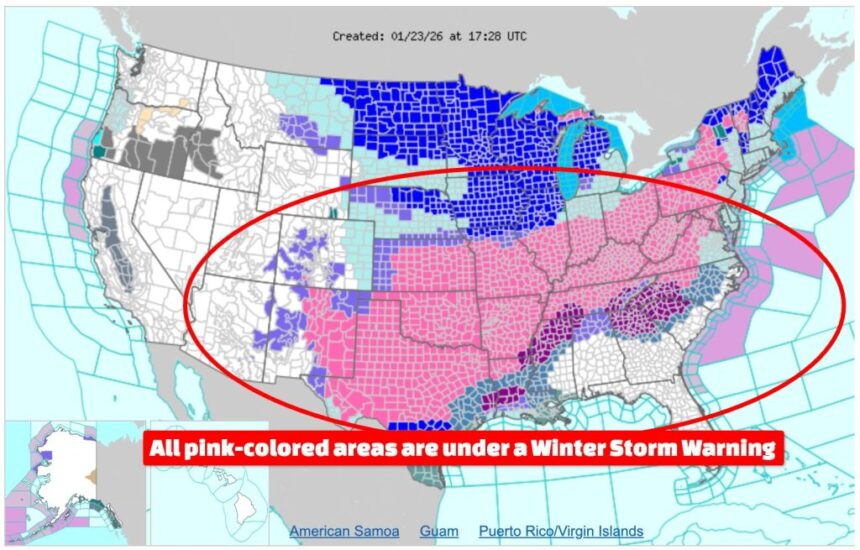
States Currently Under Winter Storm Warnings
Based on the latest advisories issued Friday, Winter Storm Warnings are in effect across all or parts of the following states. Specific impacts vary by region and elevation:
Northern Plains and Upper Midwest
Montana, North Dakota, South Dakota, Minnesota, Wisconsin, Michigan
Central Plains and Midwest
Kansas, Nebraska, Iowa, Missouri, Illinois, Indiana, Ohio
Ohio Valley and Appalachians
Kentucky, West Virginia, Pennsylvania
Northeast
New York, Vermont, New Hampshire, Maine
Mid-Atlantic
Maryland, Virginia, District of Columbia
Interior South and Tennessee Valley
Arkansas, Tennessee
Southern Plains and Southwest
Oklahoma, Texas, New Mexico
Southeast and Carolinas
North Carolina
Warnings have been issued or upgraded from earlier watches as forecast confidence increased, and additional areas may still be added as the storm evolves.
Meteorological Setup Behind the Storm
Forecasters explain that the system is being driven by a powerful upper-level trough plunging south from western Canada. As it interacts with warmer, moisture-laden air over the central and eastern United States, rapid strengthening—known as cyclogenesis—has occurred.
This dynamic setup is producing sharp gradients in precipitation type. Areas north of the storm track are seeing predominantly snow, while regions closer to and south of the track are experiencing a dangerous mix of snow, sleet, and freezing rain. In some southern locations, cold rain is expected to transition to ice or snow as temperatures continue to fall.
Travel Disruptions and Infrastructure Concerns

Transportation officials are warning that the timing of the storm could coincide with peak weekend travel, raising the risk of widespread delays. Snow-covered highways, icy bridges, and rapidly changing road conditions may make driving dangerous, particularly overnight and during early morning hours.
Airlines are also monitoring the situation closely, as snow and ice at major hub airports could lead to flight delays and cancellations. Even regions receiving moderate snowfall could experience disruptions if temperatures remain below freezing long enough for ice to persist on runways and taxiways.
Utility companies are preparing for the possibility of power outages, especially in areas where freezing rain and wet, heavy snow could accumulate on power lines and trees. Officials advise residents to charge electronic devices in advance and have backup heating options where possible.
Preparedness Guidance for the Public

Emergency management agencies emphasize that early preparation can significantly reduce risk. Households are encouraged to review emergency kits, limit non-essential travel, and check on vulnerable neighbors, including the elderly and those with medical needs.
Drivers who must be on the road are advised to carry winter safety supplies, including blankets, water, flashlights, and fully charged mobile phones. Authorities also recommend allowing extra travel time and avoiding sudden braking on icy roads.
As forecasters continue to refine the outlook, officials stress that conditions may change rapidly, and localized impacts could vary considerably even within short distances.
“The most important step right now is staying informed,” the NWS spokesperson added. “This is a storm that people should take seriously, even if they have experienced winter weather before.”
Further updates, including potential Winter Storm Warnings and Ice Storm Warnings, are expected as the system approaches.