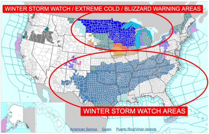
A widespread Winter Storm Watch has been issued across large portions of the United States as forecasters warn that a powerful winter system is expected to bring heavy snowfall, ice accumulation, and hazardous travel conditions over the weekend.
Meteorologists caution that the storm’s broad reach and timing could significantly disrupt road travel, air traffic, and daily routines for millions of residents.
According to the National Weather Service (NWS), the developing system is forecast to intensify as it moves eastward, drawing cold Arctic air south while pulling in moisture from the Gulf of Mexico. This combination increases the likelihood of heavy snow bands, mixed precipitation, and strong winds, particularly from the central Plains through the Midwest and into parts of the Northeast.
“This storm has the potential to create dangerous conditions over a large area in a relatively short period of time,” an NWS spokesperson said. “People should closely monitor forecasts and begin preparing now, especially if they plan to travel this weekend.”
Key highlights of the forecast include the risk of heavy snowfall exceeding several inches in some regions, possible ice accretion leading to power outages, and reduced visibility due to blowing snow.
States Currently Impacted by the Winter Storm Watch
Authorities have issued Winter Storm Watches for a wide range of states, reflecting the expansive nature of the system. While specific counties may change as the forecast evolves, the following states are currently considered at risk:
Northern Plains and Upper Midwest
- Montana
- North Dakota
- South Dakota
- Minnesota
- Wisconsin
Central Plains and Midwest
- Nebraska
- Kansas
- Iowa
- Missouri
- Illinois
- Indiana
- Michigan
Ohio Valley and Appalachians
- Ohio
- Kentucky
- West Virginia
- Pennsylvania
Northeast
- New York
- Vermont
- New Hampshire
- Maine
Parts of the Interior South
Residents in these areas are urged to stay alert, as watch areas may expand or be upgraded to warnings as confidence increases and the storm draws closer.
Storm Development and Meteorological Setup
Forecasters explain that the storm is being driven by a strong upper-level trough descending from western Canada. As it collides with warmer, moisture-rich air to the south, rapid cyclogenesis is expected, allowing the system to strengthen quickly.
This dynamic setup increases uncertainty in exact snowfall totals and precipitation types, but confidence is growing that the storm will impact multiple regions simultaneously, making it more challenging for transportation departments and emergency services to respond.
Meteorological models suggest that areas on the northern side of the system will see predominantly snow, while regions closer to the storm’s track may experience a wintry mix of snow, sleet, and freezing rain. Farther south, cold rain may transition to snow as temperatures drop.
Travel Disruptions and Infrastructure Concerns

Transportation officials are warning that the timing of the storm could coincide with peak weekend travel, raising the risk of widespread delays. Snow-covered highways, icy bridges, and rapidly changing road conditions may make driving dangerous, particularly overnight and during early morning hours.
Airlines are also monitoring the situation closely, as snow and ice at major hub airports could lead to flight delays and cancellations. Even regions receiving moderate snowfall could experience disruptions if temperatures remain below freezing long enough for ice to persist on runways and taxiways.
Utility companies are preparing for the possibility of power outages, especially in areas where freezing rain and wet, heavy snow could accumulate on power lines and trees. Officials advise residents to charge electronic devices in advance and have backup heating options where possible.
Preparedness Guidance for the Public

Emergency management agencies emphasize that early preparation can significantly reduce risk. Households are encouraged to review emergency kits, limit non-essential travel, and check on vulnerable neighbors, including the elderly and those with medical needs.
Drivers who must be on the road are advised to carry winter safety supplies, including blankets, water, flashlights, and fully charged mobile phones. Authorities also recommend allowing extra travel time and avoiding sudden braking on icy roads.
As forecasters continue to refine the outlook, officials stress that conditions may change rapidly, and localized impacts could vary considerably even within short distances.
“The most important step right now is staying informed,” the NWS spokesperson added. “This is a storm that people should take seriously, even if they have experienced winter weather before.”
Further updates, including potential Winter Storm Warnings and Ice Storm Warnings, are expected as the system approaches.


